
Mapping Volcano Eruptions With Drones
Drones have become an essential tool to map, measure and observe the extremely dangerous environments surrounding volcanic eruptions.

Researching volcanoes is a dangerous job. There’s the flying globs of molten lava, irritating volcanic smog (vog), unstable ground and sinkholes that can drop beneath your feet, volcanic glass threads called Pele’s hair that can pierce your skin and irritate your lungs, deadly invisible pools of carbon dioxide, and searing hot sulfur dioxide gas that can choke and kill you, just to name a few hazards.
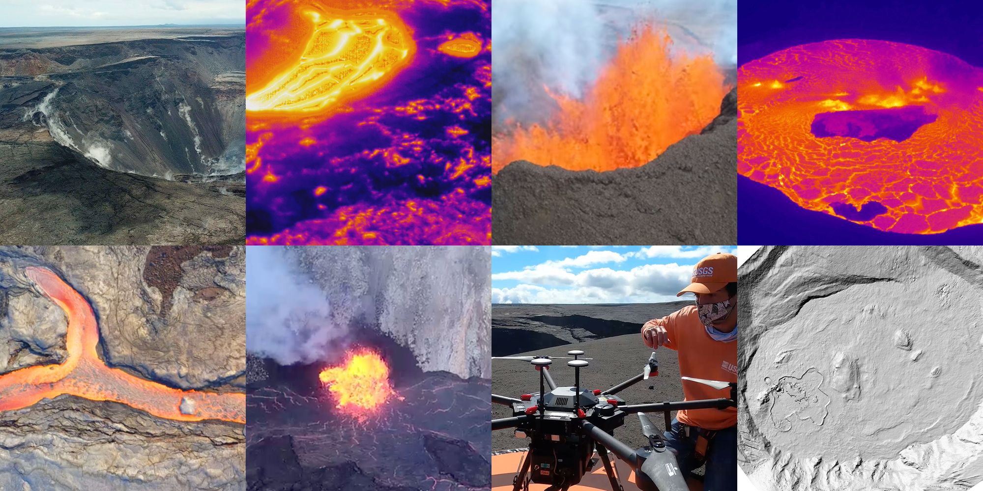
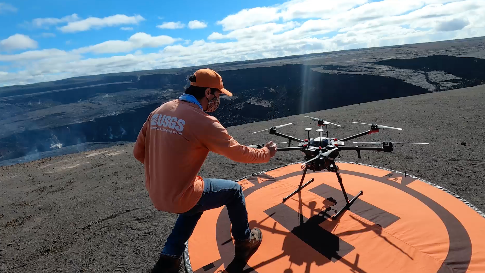
To help minimize some of these risks, and record observations that would otherwise be difficult or impossible in a helicopter, United States Geological Survey (USGS) researchers have embraced the drone as an essential tool to observe the chaotic, rapidly changing environments surrounding volcanic eruptions near the summit of Hawaii’s Kīlauea Volcano.
The dataset featured in this post comes from a FOIA request submitted to the USGS from data journalist (and licensed drone pilot) Ben Welsh. The data contains over 800 photographs from an October 2022 Uncrewed Aircraft System (UAS) mission at Halema'uma'u crater. Welsh also included a cool downloadable 3-D printable model of the crater.
Mapping and measuring
One of the main tasks that these USGS drones are used for is photographing the entire area of the crater where the volcanic activity is most active. The photos taken by the drones’ cameras aren’t just for capturing dramatic scenes of exploding lava fountains (though there is plenty of that). The drones capture hundreds of hundreds of photos sequentially, which are then processed using a technique called “structure from motion”. This technique matches up the sequential images, aligning the photos based on landmarks in the images, computing the differences from frame to frame, which are used to generate the 3-D shape. USGS uses an app called Agisoft MetaShape to process these images into a model, a technique which is also known as “photogrammetry”.
The same sort of detailed scans can also be captured using LiDAR, but that usually involves a piloted aircraft with more expensive scanning gear. Being able to safely fly over such a dangerous environment more frequently without risking pilots or expensive aircraft allows for more frequent scanning and a better understanding of the rapid changes occurring in the crater.
I spoke with Michael Zoeller, who is a geologist and a GIS analyst working at the USGS’s Hawaiian Volcano Observatory in Hilo, Hawaii. Zoeller pilots drones in the field, and also processes imagery and creates mapping products in his role.
“During the eruption that ran from late 2021 to the end of 2022 we were probably doing [drone flights] once a month, alternating with the helicopter flight. We would do one drone flight, then two weeks later do a helicopter flight, two weeks after that I do a drone flight and kind of just keep running through that cycle more or less”, explained Zoeller.
Asked if he ever imagined his job would involve flying drones over volcanoes when he was a kid, Zoeller replied “All those years of playing video games in high school and college…it kind of paid off.”
“We relied on helicopters for aerial observations of our volcanoes here for decades. But drones have come along and they provide an alternative to helicopters that allow us to deploy more quickly at greatly less cost and, and quite importantly with much less danger to the occupants,” said Zoeller.
In addition to the regular camera, the drones are also usually equipped with a thermal camera, which can measure the searing temperatures of the surfaces being photographed from a safe distance.
Other hazardous conditions such as corrosive sulfurous gasses would wreak havoc on helicopter engines, but have less of an effect on battery powered drones with electric motors. “We can kind of park right in that volcanic gas plume and just sit there for 10, 15 minutes collecting data the whole time. And that's stuff that we could never ever get with a helicopter,” said Zoeller.
Zoeller added that while the USGS has had drones fall from the sky, they have been able to recover and reuse them all. That is especially important as federal procurement rules have restricted the use of federal dollars to purchase drones manufactured in China, which currently dominates the drone industry.
Recent Eruptions at Halemaʻumaʻu Crater
The past few years have seen lots of interesting volcanic activity at the Kīlauea summit caldera. Sitting within the larger caldera lies the Halemaʻumaʻu pit crater.
In 2018, a 6.9 magnitude earthquake in the Puna district (on the Big Island) was the start of a major eruption of Kīlauea in the East Rift Zone. The resulting lava flows destroyed 700 homes and caused more than $800 million in property damage, making it the most destructive volcanic event since Mount St. Helens erupted in 1980.
An estimated cubic kilometer of lava flowed towards the sea during the 2018 event, which drained a long-standing lava lake below the Halemaʻumaʻu crater floor, causing it to collapse.
After the collapse, a water lake developed at the bottom of the crater for about a year. The 130 ft. (40m) deep lake evaporated over the period of two hours when a December 2020 eruption spilled lava from three vents to fill the former lake.
In September of 2021, an eruption in Halemaʻumaʻu featured lava shooting up in dramatic 200 ft (61m) high fountains, and seeping through multiple fissures in the crater floor and walls. The eruption lasted just over two months.
In January of 2023, another two month-long eruption in the crater was documented, flowing new lava onto the crater floor.
During this period, the floor of the crater has continued to rise, explained Zoeller. “We've just seen this gradual caldera filling, which is not unsurprising. A similar process is documented to have happened in the 1800s.” According to the USGS, in the year after the 2021 eruption, the crater floor rose up 470 feet (143m), as 29.2 billion gallons of lava filled the crater.
The swelling of the crater floor can be seen in this time series of digital elevation model (DEM) files, many of which were captured via drone. You can see huge islands of rock floating on the flowing lava lake as it spews out of fissures in the crater wall.
Confirming observations from the past
The use of these modern tools to measure short-term changes in the structure of the summit crater, but they also help fill in a record of past observations.
“We're seeing pretty major changes on short timescales right now. And because like some of these processes were kind of seen but not well documented in the 19th century, it's been really interesting for us because seeing it now has helped us kind of figure out some of the stuff that was described by early missionaries,” said Zoeller.
“They saw this endogenous uplift and the crater was slightly domed in the middle because of like the viscosity of the lava and like, ‘OK, yeah!’, it kind of makes sense that what they were talking about,” said Zoeller.
What's next?
Regarding the current calm at the crater, Zoeller said “As to how long that's gonna go on, you know nobody really knows. It might keep filling the summit, it could eventually transition into one of the rift zones again.”
You can check out a live webcam with a fantastic shot of the Halemaʻumaʻu crater here. The latest daily update from the Hawaiian Volcano Observatory notes, “Kīlauea volcano is not erupting, and no active lava has been observed since March 7, 2023.”
Zoeller said forecasting Kīlauea is hard to predict because “...we have a documented history of this volcano for 240 years, but that's a very small sliver of time when this thing's been erupting for hundreds of thousands of years.”
Special thanks to fellow news nerd Ben Welsh aka palewire aka KF0IA for filing the FOIA request for this drone imagery, and for sharing his drone pilot knowledge. As Ben says, "Always be filing." 🌋
For this post, I imported the photographs from the October 2022 UAS flight that Ben Welsh FOIA'd into Agisoft MetaShape. I was then able to export an orbiting video of the crater as a 3-D model.
I also used QGIS to load the DEM files (GeoTIFF) and render them as hillshade rasters. I then appended the date extracted from the filename in
Imagemagick, and animated the annotated frames with ffmpeg. I also used ChatGPT for some of the
Imagemagick / ffmpeg commands, which it excels at and saves me from looking up exactly what I did last time (though I still usually have to do that to some degree).You can subscribe to our newsletter to get future posts delivered to your inbox for free. 👉🏻 📫 Subscribe now.
Sharing is caring
📣 If you think your followers or friends may like it, please consider sharing it.
🙋🏻♀️ If you have any suggestions, comments or requests, please email them to beautifulpublicdata@gmail.com
Thanks for reading!
- Jon Keegan (@jonkeegan)