
The Naughty Words the FAA Removed From the Sky
New FOIA records from the FAA shed light on the frantic effort in 2015 to rename navigation waypoints related to Donald Trump and reveal the list of naughty waypoint names that were changed over the years.

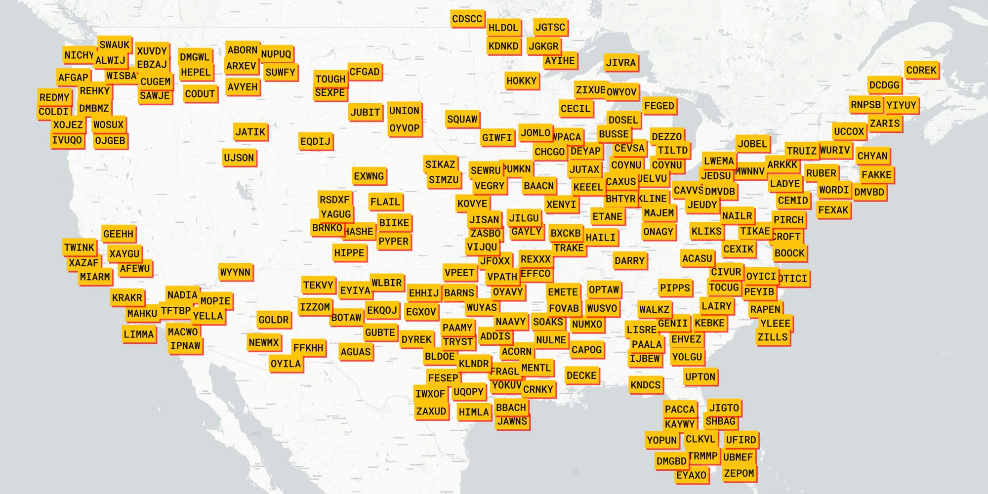
Recently I wrote about the Federal Aviation Administration’s (FAA) fantastically information-dense navigation maps. In that story, I explained the interesting system of navigation “fixes”— specific points of latitude and longitude in the sky used by pilots to navigate. These fixes have five-letter names and are designed to be pronounceable for clarity over noisy radios. The names can be colorful, often referencing pop culture, such as GNDLF (Gandalf from The Lord of the Rings), JJEDI (the Jedi knights from Star Wars), or SNFLD (Jerry Seinfeld). They can also be inside jokes or even slightly naughty.
 Jon Keegan
Towards the end of the story, I noted that these waypoints have occasionally been the source of controversy. In 2015, the FAA renamed several waypoints on the east coast of Florida near a certain presidential candidate’s waterfront estate. The waypoints that were renamed were DONLD, TRMMP, and UFIRD.
Curious about the details of this change and other waypoint replacements over the years, I filed a Freedom of Information Act (FOIA) request with the FAA before publishing my initial story. The records I received back contain a list of the 368 waypoints that have been renamed since 2015 and included some interesting details surrounding the episode which to my knowledge have not been reported before.
Due to the fact that many civil servants have been unfairly harassed for their work having anything to do with the former president, I am not using their names or specific titles.
Here's a searchable table of the waypoints that were renamed:
“This is on fire right now.”
It had only been a month since Donald Trump announced his first presidential campaign. NBC had already cut ties with Trump after he called Mexican immigrants criminals and rapists. For two weeks in July 2015, a group of FAA employees and administrators frantically emailed each other in response to a brewing crisis.
“So....
Please take a cursory look at the cost involved so we have that information.
Karen Schwartz, a stringer for the New York Times, asked if we are considering renaming three air traffic fixes near Palm Beach International Airport because of Donald Trump’s recent “racist statements about Mexicans.” The fixes were named DONLD, TRMMP and UFIRD a number of years ago because they are near Trump’s house. We are coordinating a response,” wrote an administrator in FAA Mission Support Services."
According to emails obtained through my information request to the FAA, the agency administrators’ first course of action after a meeting about the issue was to determine the cost of renaming the three waypoints.
An official at FAA Aeronautical Information Services wrote:
“Per our telecom, can you provide a listing of actions necessary to complete the proposed changes to FIX names at Palm Beach International. We are just gathering information for what this would cost AIS if we were to be asked to complete the work, This is not a request to begin action. Based on the email below, a quick turnaround is requested”
The sense of urgency came through in the messages. Shortly after this email, one FAA employee wrote:
“This is on fire right now.”
One employee noted that the Trump waypoints were originally published in December 2009. After some back and forth, it was determined that the change would take 50 hours of work, estimated to cost $11,443.

On July 9, 2015, The New York Times published a story by Karen Schwartz about the change with the headline “F.A.A. to Drop Donald Trump-Related Navigation Codes.”
Four days later, FAA employees circulated draft language for a statement about the change:
“Aeronautical Information Services (AIS) helps the NAS remain safe and respectful Mission Support Services (MSS) tasked AIS to quickly provide a cost estimate for changing three navigation fix names published on five Standard Instrument Departures (SIDs) at West Palm Beach, FL (KPBI). The fix names UFIRD, DONLD, and TRMMP originally published in 2009 are listed in consecutive order on the IVNKA ONE Departure. However, they are not published in any consecutive or sequential order on the BUFIT ONE, LMORE ONE, MIXAE ONE, or the TBIRD ONE Departures. Therefore, there offensive and derogatory nature went unnoticed until the recent comments of Donald Trump’s speech. These three fix names are being fast track scheduled to be changed when the five SIDs are amended in 10/15/15. The five amended SIDs were already scheduled to publish on 12/10/15 but the politically sensitive nature of these fix names warranted the additional workload changes and coordination for an earlier publication date.”
The next day, another Trump related waypoint was flagged for renaming:
“While we are removing Donald Trump, should we also rename the Ivanka SID? (it's his daughter).”
The suggestion was accepted.
On December 10, 2015, the new waypoints appeared on FAA charts.
The emails show that in October 2016, the conservative activist non-profit Judicial Watch re-filed a FOIA request to the FAA which it had originally sent in July 2015, shortly after the story of the renaming broke. In the emails, it says that Judicial Watch claimed that the first request went unanswered and was again requesting all records related to the changes of the four Trump waypoints (DONLD, TRMMP, UFIRD and IVANKA) as well as some other waypoints: ICICL, CURTS (in Alaska), LEBRN (in Ohio) And INEPT (in Pennsylvania).
It is unclear if that request was ever successfully fulfilled or why they were interested in those particular waypoint changes.
In January 2017, Trump was sworn in as President. Only 11 days later, the waypoint controversy flickered back to life with an interesting email.
“Yes, –––– called me yesterday and mentioned that someone (he didn’t say who) was asking him to reserve some specific fix idents: TRMMP, IVNKA, DONLD, UFIRD for use on a procedure at Palm Beach, FL.”
The sender then reminded the recipient of the controversy and the action the agency took in response.
“When I mentioned to Jeff the sensitive nature of the names and the background of their being re-named he decided that he did not want to re-reserve the idents.
It appears that someone is interested in re-establishing those fixes at the same arpt[sic] as they were prior to being re-named.”
Decoding the Waypoints
In my FOIA request, I asked the FAA to also include the reasons for each waypoint change, but they didn’t provide them. So I set out to decode what was behind some of these changes.
For some waypoint names, it was pretty clear why the FAA might want to clean them up. In Maryland, there was AWFUL and Memphis, TN had BLEWS. The FAA might have wanted to steer clear of politics by renaming UNION, just north of Rapid City SD.
Of course, all of these renamings might have innocent explanations, or might have been named for completely different reasons, but for now, we can only speculate.
The process of changing these waypoints can take a while, but the changes are lined up for the next scheduled publishing date, as these maps are updated at regular intervals. Examining groups of waypoints published on the same day might indicate someone searching for a particular group of unsavory waypoints.
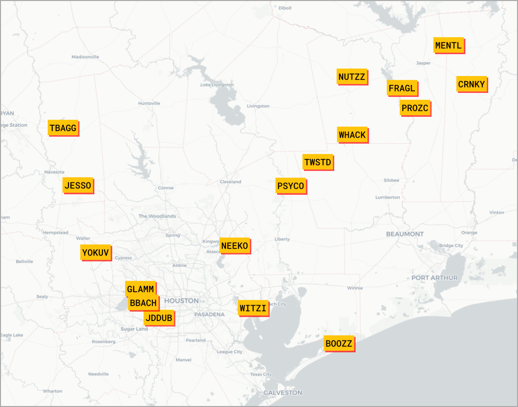
For example, on June 25, 2015, a batch of mental health-related waypoints were renamed. In a line heading northeast out of Houston, TX, there were: CRNKY, FRAGL, MENTL, NUTZZ, PROZC, WHACK, TWSTD, and PSYCO.
Sometimes just looking at the waypoint names may not reveal their meaning, but often, considering the name in the context of its location lets you in on the gag.
Outside Dallas, TX a waypoint named DEBBB was removed, an apparent reference to the porn film “Debbie Does Dallas”. Texas also renamed TRYST, TBAGG and BOOZZ. Texas had the most changed names in the dataset.
Near San Francisco, there were TWINK and NUUTT, while Missouri had GAYLY.
South of Bakersfield, CA, there was KRAKR. Near Racine, WI, there was JUTAX and Maryland had DIXXE.
Sometimes you have to say the waypoint name out loud to understand why it might have been banned, such as Florida’s KAYWY (like the jelly?) or Missouri’s FELUR. Florida also had SHBAG.
In 2019, Nevada’s WYNNN was removed, perhaps to further scrub references to billionaire hoteliers from the database.
New York had RUBER and North Carolina’s RAPEN was also changed.
Sometimes you need to see groups of these waypoints together, as they are meant to be read in a sequence as a pilot is flying into or out of an airport.
Southwest of Cleveland, OH, there was a cluster of now removed waypoints:
WHHAT, THATZ and MYMOM.
In Los Angeles, some waypoints were renamed not to remove negative associations but to honor basketball legend Kobe Bryant and his daughter Gianna, who were among nine people killed when a helicopter crashed in Calabasas, CA, in January 2020. On May 20, 2021, the waypoints were renamed GIGII and KOBEE.
Do you know the backstory to any of these waypoint names? Please reach out if you do!
For this post, I loaded up the CSV I received from the FAA into QGIS, which is how I generated the header graphic. I then used the qgis2web plugin to export a simple Leaflet map.
I used this "Convert Outlook .msg Files to .eml (MIME format)" Python script to convert some of the email messages I received in the FOIA documents.
I tried to use ChatGPT to look through the list of waypoints, and consider the sound of the pronunciation (which it could do surprisingly), the location and the word to find any meaningful waypoints. It did make some connections when I asked about particular waypoint names, but it failed to find any meaningful ones I wasn't already aware of.
The original data and a cleaned up version listing the renamed waypoints can be found here: https://github.com/jonkeegan/faa-waypoints-renamed
You can subscribe to our newsletter to get future posts delivered to your inbox for free. 👉🏻 📫 Subscribe now.
☕️ Buy me a coffee
Say thanks with a one time tip.
Sharing is caring
📣 If you think your followers or friends may like it, please consider sharing it.
👕🖼️ Buy Beautiful Public Data merch on our Etsy shop
Unique t-shirts and prints inspired by our stories
🙋🏻♀️ If you have any suggestions, comments or requests, please email them to beautifulpublicdata@gmail.com
Thanks for reading!
- Jon Keegan
Bluesky: @jonkeegan.com
Mastodon: mastodon.social/@jonkeegan